Geography
Intent
At Saint James Primary School, we believe that Geography is a subject that not only sparks children's fascination and curiosity about God’s world and its people, but also embodies our Christian values of love, respect, and courage.
Our aim is to equip our students with a deep understanding of key physical and human geography, as well as locational knowledge, enabling them to comprehend their place in the world in relation to other locations, all while embracing and demonstrating our Christian values.
We teach our students to approach the study of the world with love, recognizing the interconnectedness of all people and embracing diversity. We encourage them to show respect for the environment, for different cultures and traditions, and for the unique characteristics of places.
In addition, we foster courage within our students as they explore and investigate the causes and consequences of human impact on the planet. They learn to confront environmental challenges, such as global warming and natural disasters, with resilience and determination. We inspire them to take action, to make purposeful changes in their own lives and communities, guided by their understanding of the world and their Christian values.
I embody the spirit of a Geographer at Saint James, as I...
• Ask thought-provoking questions and demonstrate curiosity about the world and its people.
• Collect and analyse data through engaging fieldwork experiences, understanding the importance of gathering information with respect.
• Interpret a range of geographical information, including maps, with a sense of appreciation for the diversity of the world.
• Possess knowledge of significant places on both a global and national scale, acknowledging their historical, cultural, and environmental significance.
• Compare and contrast geographical places, recognizing and celebrating their unique characteristics, fostering a spirit of respect.
• Evaluate the impact of human geography on the world, understanding our actions and the importance of responsible decision-making.
• Comprehend the processes that shape physical geographical features, appreciating the wonders of creation and the role we play in preserving them.
Through our comprehensive Geography curriculum, we aim to foster a deep appreciation for the world, nurture global citizens rooted in Christian values, and empower our students to make a positive impact in their communities and beyond. By integrating love, respect, and courage into our teaching and learning, we strive to shape compassionate and responsible individuals who embrace their role as stewards of the Earth, inspired to make a difference.
Implementation
At Saint James School, we have designed a comprehensive geography curriculum that aims to provide students with a strong foundation in understanding people, culture, and communities. Our curriculum builds upon the early years' learning by introducing students to their environment and encouraging them to compare it with other countries.
Here are some key features of our geography curriculum:
• Geography lessons are taught in Years 1-6, alternating with History projects, to ensure a broad and balanced curriculum.
• Each year group participates in 2-3 geography projects per year, allowing students to explore different topics and regions.
• Geography projects consist of approximately 6 lessons, which are taught once a week in Key Stage 1 and blocked in 3 afternoons in Key Stage 2.
• Each geography project revolves around a key enquiry question, providing a focused and engaging learning experience for the students.
• At the end of each geography project, students showcase their knowledge and understanding through various forms of assessment, such as essays, debates, or presentations.
• To assess retention and application of knowledge, students also complete an assessment beyond the point of teaching, typically in the final week of the following half term.
• Our geography curriculum aligns with the National Curriculum and we have the support of curriculum specialists to help with curriculum mapping from Hampshire.
• Geography projects are purposeful and serve as the thematic focus for each half-term project, allowing for meaningful connections across different subject areas.
• We emphasize the importance of recording geography learning in Humanities books, providing a tangible representation of students' progress.
• When necessary, we collect photographic evidence, including field trips, to enrich students' understanding of their immediate local area and beyond.
• A progression of skills document guides the teaching of specific geography skills in each year group, ensuring a coherent and progressive learning journey.
• Sticky knowledge and skills are clearly identified, enabling students to track their learning and progress.
• The vocabulary of geography is explicitly taught, empowering students to communicate effectively and confidently in the subject.
• Our curriculum actively incorporates fieldwork and trips, allowing students to explore and investigate their environment, both within the school grounds and in locations such as Hedge End and Southampton.
• In geography, students are encouraged to interpret a variety of reading materials, including atlases, non-fiction texts, and online resources such as DigiMaps. This cultivates their ability to conduct research and learn independently.
• By implementing this comprehensive and engaging geography curriculum, we aim to inspire our students to become lifelong learners, critical thinkers, and responsible global citizens.
Impact
At Saint James School, our values of learning with love, reflecting with respect, and caring with courage are interwoven into our Geography curriculum to create a meaningful and impactful learning experience for our students.
-
Key geographical skills are identified using our progression of skills document, which guides our teachers in assessing students' progress throughout the project. We also identify sticky knowledge, ensuring that students have a solid foundation of knowledge for their projects.
-
Throughout the project, children demonstrate their application of knowledge and skills by answering the enquiry question. This allows our teachers to assess how well the children have achieved the expected outcomes. We also use assessments 'not at the point of teaching' to check how well children can retrieve and retain key knowledge from previous projects, ensuring long-term retention of learning.
-
To ensure the quality of our curriculum provision, our geography subject leader monitors the implementation of the curriculum through various methods such as lesson observations, learning walks, planning scrutiny, work sampling, and pupil conferencing. This allows us to continuously improve and provide the best learning experience for our students.
-
Our geography subject leader also plays a crucial role in supporting the creation of our curriculum overviews and identifying sticky knowledge and vocab within each unit.
-
Additionally, we regularly review assessment outcomes to evaluate the impact of our geography curriculum. This helps us to identify areas for improvement and ensure the highest possible outcomes for our students.
By incorporating our values of learning with love, reflecting with respect, and caring with courage into our Geography curriculum, we create a learning environment that promotes inquisitiveness, critical thinking, and a profound appreciation for the God's world around us.
Curriculum overview
A summary of the Geography curriculum can be downloaded, or browsed in the accordian container below:
!
WarningFor additional information regarding the curriculum please
email our Curriculum Leader
Our Wonderful World
What is our Country?
NC Objectives:
Locational Knowledge:
Name and locate the world’s seven continents and five oceans;
Understand geographical similarities and differences through studying the human and physical geography of a small area of the United Kingdom, and of a small area in a contrasting non-European country.
Use and locational and directional language [for example, near and far; left and right], to describe the location of features and routes on a map.
Sticky Knowledge:
To know the names of and locate the seven continents of the world.
Know the main differences between a place in England and that of a small place in a non-European country.
Identify explain what physical features are
To understand and use the terminologies: left and right; below, next to
Key Vocab:
Asia Africa North America South America Antarctica Australia/ Oceania/ Australasia Europe Arctic Southern, Pacific Atlantic Indian
Weather
What is the weather like?
NC Objectives:
Physical Geography:
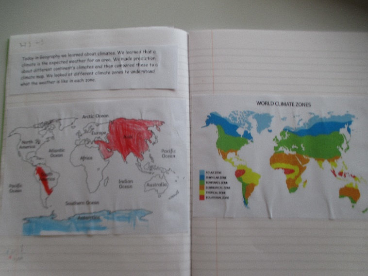
To identify seasonal and daily weather patterns in the United Kingdom and the location of hot and cold areas of the world in relation to the Equator and the North and South Poles
Sticky Knowledge:
Know features of hot and cold places in the world.
Recognise main weather symbols.
Recognise main weather symbols.
Know where the equator, North Pole and South Pole are on a globe.
Know which is N, E, S and W on a compass .
Know their personal address.
Key Vocab:
Compass, Compass points: East North South West Fieldwork plan aerial photograph map key symbols Equator hot/cold Direction key Country Continent globe atlas Address Right/ left patterns characteristics surrounding seas contrasting non-European W
Topic: West End Wanderers
Our Local Environment
Where are we?
NC Objectives:
Place Knowledge:
Understand geographical similarities and differences through studying the human and physical features of a small area of the United Kingdom
Sticky Knowledge:
To learn about their school, and what it is like there what is it like?
To learn what it is like in their local area through going on local walks (fieldwork)
To explore what makes their local area significant – Our local area is significant because…
To explore where people live and work in their local area by looking at different types of homes and jobs
To understand what a map is and draw a map of the local area using symbols and keys
To explore things they like and do not like about their local area and suggest changes for the future
Key Vocab:
human features, city, town, village, factory, farm, house, office, port, harbour shop Capital city country
Class Countries
What is your class country like?
NC Objectives:
Use world maps, atlases and globes to identify the United Kingdom and European class countries.
Understand geographical similarities and differences through studying the human and physical geography of a small area of the United Kingdom
Sticky Knowledge:
To know the names of and locate the seven continents of the world – how can we make this progress from Y1 objective?
To be able to name and locate the five oceans of the world.
To know the name of and locate the four capital cities of England, Wales, Scotland and Northern Ireland.
To identify the location of a number of European countries
Key Vocab:
world, Europe, map, atlas, city, village, town, agriculture, arable farm, high street, vegetation, climate
Kings and Queens
The United Kingdom
Where does the King live?
NC Objectives:
Locational Knowledge:
Name, locate and identify characteristics of the four countries and capital cities of the United Kingdom.
Understand geographical similarities and differences through studying the human and physical geography of a small area of the United Kingdom.
Use simple compass directions and locational and directional to describe the location of features and routes on a map (fieldwork)
Sticky Knowledge:
To become familiar with maps of the United Kingdom and learn to recognise its shape
To locate the United Kingdom world map and a globe
To identify England, Northern Ireland, Scotland and Wales, as well as their capital cities
To locate their own town/city within the United Kingdom
To develop contextual knowledge of the location of significant places within the United Kingdom London, Scotland - Edinburgh, Wales - Caernarfon Castle
To recognise the individual flags of the four countries, as well as the Union Jack
To begin to develop an understanding of the concept of union
Key Vocab:
England Scotland Wales N. Ireland Belfast Cardiff Edinburgh London North/ Irish/ Celtic Seas English Channel
Titanic: The Unsinkable
From Southampton to New York!
NC Objectives:
Locational Knowledge:
Name and locate the world’s seven continents and five oceans.
Geographical Skills:
Use world maps, atlases and globes to identify the United Kingdom and its countries, continents and oceans.
Sticky Knowledge:
To learn the names of the world’s seven continents and five oceans
To recognise and identify the world’s seven continents and five oceans on a globe and on a world map
To understand the location and significance of the Equator, the Arctic and Antarctic Circles and the Tropics
To identify hot and cold places around the world
To explore the key human and physical features of each of the seven continents – what key features do we want them to remember?
Key Vocab:
Asia, Africa, North America, South America, Antarctica, Australia, Oceania, Australasia, Europe, Arctic Southern, Pacific Atlantic
</text>
East Africa
Let’s Compare!
What is the same and what is different? – Kingali
NC Objectives:
Place Knowledge:
Compare a local city/town in the UK with a contrasting city/town in a different country;
Geographical Skills/ Fieldwork:
Use aerial photographs and plan perspectives to recognise landmarks and basic human and physical features; devise a simple map; and use and construct basic symbols in a key;
Sticky Knowledge:
Identify the physical features such as mountain; lake; island: valley: river; cliff; forest and beach.
To Know the main differences between city, town and village – such as…
To be able to explain some of the advantages and disadvantages of living in a city or village. – what are the advantages / disadvantages?
Key Vocab:
Non- European village, urban, rural, agriculture, farms, landmarks, mountain, river, valley, climate
Africa
Why is Africa so special? - Johannesburg
NC Objectives:
Describe and understand key aspects of types of settlements and land use,
Identify the position and significance of latitude, longitude, Equator, Northern Hemisphere, Southern Hemisphere, the Tropics of Cancer and Capricorn,
Sticky Knowledge:
To know the names of four countries from the southern and four from the northern hemisphere.
To be able to locate countries and given cities on maps.
To know at least five differences between living in a UK city and Johannesburg.
To compare the human activities of each of those 2 cities. (similarities and differences)
Key Vocab:
tropics, tropical, of latitude, longitude, Equator, Northern Hemisphere, Southern Hemisphere, the Tropics of Cancer and Capricorn,
The Iron Man
Coastal Features
What is happening to our coastline?
NC Objectives:
Identify human and physical features - coasts. Use patterns to understand how the coast line has changed over time.
Sticky Knowledge:
To Identify the physical features of coasts.
To recognize how coasts have changed over time.
To remember how they used mapping skills to look for changes in the coast.
Key Vocab:
Digimap, coastal, erosion, Bay, cape, cove, Headland, peninsula, cliff, arch, cave, stack, stump, beach, dunes, spit, lagoon
Hampshire Our County!
Our Local Area:
What is unique about our local area?
NC Objectives:
Name and locate counties and cities of the United Kingdom, identifying human and physical characteristics including hills, mountains, rivers and seas, and how a place has changed;
Understand geographical similarities and differences through the study of human geography of a region of the United Kingdom;
Use key vocabulary such as Sherwood Forest, Sheffield, city, Yorkshire, physical features, human features, landscape, feature, population, land use, retail, leisure, housing, business, industrial, agricultural
Sticky Knowledge:
This needs to be a progression from the unit on local area that happens in year 1
Key Vocab:
country, county region, topography, agricultural, borders, city, farming, hamlet, industrial, land use, local, population, residential, rural, urban, settlement, jobs, tourism
deciduous forests, coniferous forests, environment, Greenwich meantime
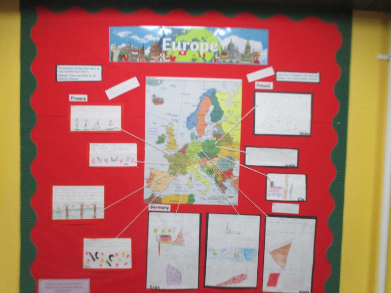
Class Countries – Scandinavia
What is life in Scandinavia like compared to living in the UK?
NC Objectives:
Locate the world’s countries, using maps to focus on Europe (including the location of Russia)
Understand geographical similarities and differences through the study of human and physical geography of a region of the, a region in a European country,
Describe and understand key aspects of :physical geography, including: mountains
Use maps, atlases, globes and digital/computer mapping to locate countries and describe features studied;
Explore similarities and differences, comparing the human geography of a region of the UK and a region of Europe
Explore similarities and differences comparing the physical geography of a region of the UK and a region of Europe;
Sticky Knowledge
To identify the Scandinavian countries and capitals
To be able to explain the key physical features of Scandinavia
To explain how the physical features and climate affect the human activity of Scandinavians
To look at similarities and differences between the UK and Scandinavia
Key Vocab:
wind, non-renewable, solar power, energy, turbines, economic activity, filter, pollution, settlement, settler, site, need, shelter, mountain, fault-block mountain, dome mountain, volcanic mountain, plateau mountain
Charlie and The Chocolate Factory
Fair Trade
Should all chocolate be fair trade? Ecuador Focus
NC Objectives:
Use key vocabulary to demonstrate knowledge and understanding in this strand: goods trade carbon footprint
Describe and understand key aspects of:
Human geography including: economic activity, including trade links, and the distribution of natural resources including food and water
Describe and understand key aspects of: climate zones, biomes and vegetation belt
Sticky Knowledge
Fairtrade works with farmers and workers so they can improve their living standards, invest in their communities and businesses, and protect our shared environment.
Fairtrade achieves this by rallying a global community of millions – farmers and workers, supply chain partners, brands, retailers, shoppers, schools, government – to pay fair prices and uphold fair production standards and practices.
Fair prices provide an immediate lifeline for farmers and workers struggling with low incomes and disadvantaged by global trade.
People, objects and even countries all have a carbon footprint.
Environmental scientist Laura Young thinks of your carbon footprint as being an environmental maths sum, in which you add up all of the greenhouse gases you release into the atmosphere as part of your daily life.
Food miles are a way of attempting to measure how far food has travelled before it reaches the consumer. It is a good way of looking at the environmental impact of foods and their ingredients. It includes getting foods to you, but also getting waste foods away from you, and to the landfill!
To explain the distance goods need to travel to meet the demands of the global market.
To understand how climate plays a role in our every growing global market. how does it?
Ecuador’s high-quality ‘fine’ cacao is sought after for its fruity, floral tones, and accounts for approximately 60% of fine cacao sold globally, according to Ecuadorian government figures. Only around 5% of the world’s cacao is classed as ‘fine’; the rest — cheaper, ‘bulk’ cacao — is used for mass production.
Southampton, City Of Southampton → Ecuador – 5,775 miles
Key Vocab:
customers, economic activity, employment, export, fair trade, globalization, trade, wages, distribution, global, region, air miles
Raging Rivers
What is the same and what is different?
River Test – Totten & River Blackwater
Compared with River Seven & River Thames
NC Objectives:
Name and locate counties and cities of the United Kingdom, geographical regions and their identifying human and physical characteristics, key topographical features rivers, and land-use patterns; and understand how some of these aspects have changed over time;
Use fieldwork to observe and present the human and physical features in the local area using sketch maps plans and digital technologies
Sticky Knowledge
To name the features of river.
To name famous rivers of the world and identify there location.
To explain what they learned about local rivers using Google Maps and DigiMaps.
Key Vocab:
atmosphere, condensation, evaporation, water cycle, precipitation, saturated, run off, bank, bed, channel, confluence, current, delta, downstream, deposition, depth, erosion, estuary, flood, flood plain, mouth, source
South America
Where in the world is South America and what is it like?
NC Objectives:
Use maps to locate the world’s countries with a focus on South America, concentrating on their environmental regions, key physical and human characteristics, countries, and major cities
Recap the position and significance of latitude, longitude, Equator, Northern Hemisphere, Southern Hemisphere and use longitude and latitude to find locations on a map;
Geographical similarities and differences through the study of human geography of a region South America;
Understand geographical similarities and differences through the study of physical geography of a region of South America
Sticky Knowledge
Know the names of, and locate, a number of South American countries
To know that different parts of the world have different climates, and to be able to name and locate some of the different climates in South America.
To explain the features of the water cycle.
To know the name of and locate a number of the world’s longest rivers.
To know and label the main features of a river.
To know the names of and locate at least eight counties and at least six cities in the UK.
Key Vocab:
latitude, physical features, climate, human geography, land use, settlement, economy, natural resources. Amazon rainforest. longitude, latitude, time zones, biodiversity, biome, ecosystem flora, temperate, humidity
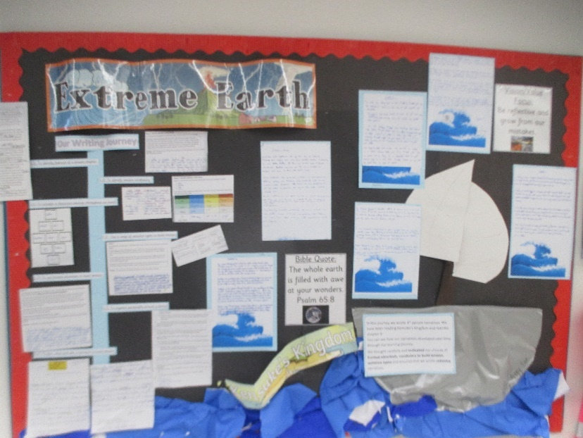
Extreme Earth
Earthquakes, Flooding and Volcanoes
What is extreme weather?
NC Objectives:
Physical Geography:
Use key vocabulary to demonstrate knowledge and understanding in this strand: atlas, index, coordinates, latitude, longitude, contour, altitude, peaks, slopes, continent, country, city, North America, South America, border, key.
Describe and understand key aspects of:
Physical Geography, including: climate zones, biomes, volcanoes, tornadoes, tsunamis, earthquakes
Use fieldwork to observe, measure, record and present human features using a range of methods, including sketch maps, plans and graphs, and digital technologies
Sticky Knowledge
To know what causes an earthquake and where they are most likely to occur and why.
To label the different parts of a volcano.
To identify and name examples of extreme weather.
*To be able to locate Scandinavia’s countries and major cities on a world map. *To know how to use graphs to record features such as temperature or rainfall across the world
Key Vocab:
environmental disaster, settlement, mantle, outer core, inner core, magma, volcano, active, dormant, extinct, earthquake, epicentre, shock wave, magnitude, tsunami, tornado, climate, tropics, deforestation
Lost in the Universe
What are the universes most valuable resources and why?
NC Objectives:
Recap longitude and latitude, time zones tropics Use positional language
To know what natural resources are (food, minerals and water)
Know uses of some natural resources
Identify and locate countries who are major producers
To know why can’t produce all of the food we need.
Identify how our food is transported from farm to shop
Identify top 5 produces and consumers of a mineral Water – know the distribution of water.
Sticky Knowledge
Describe and understand key aspects of the distribution of natural resources including energy, minerals and water
To use maps, atlases and globes to locate countries and describe features studied
Use the eight points of a compass, symbols and keys to build their knowledge of the wider world Use fieldwork to observe, measure, record and present the human and physical features in the local
Key Vocab:
Use key vocabulary to demonstrate knowledge and understanding in this strand: services, goods trade, natural resources, food miles, carbon footprint, minerals, water
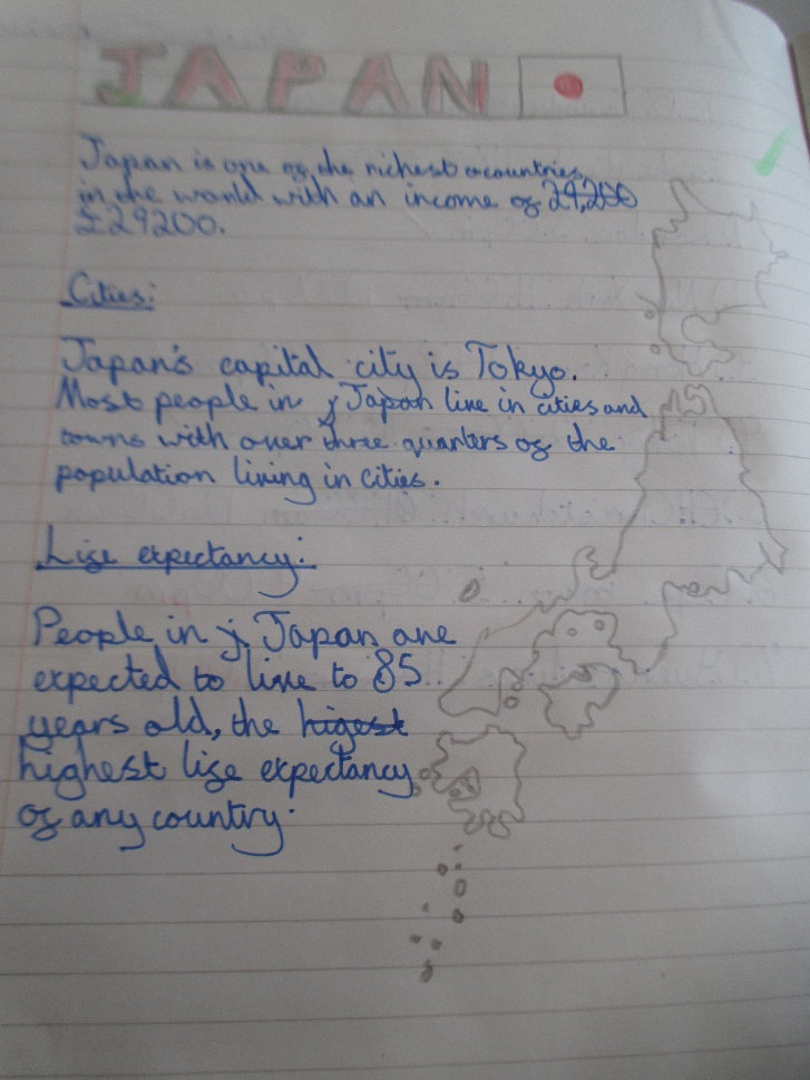
Asia
Where is Asia and what is it like?
What is latitude and longitude?
NC Objectives:
Name and locate counties and cities of the United Kingdom, geographical regions and their identifying human and physical characteristics, key topographical features (including land-use patterns; and understand how some of these aspects have changed over time;
Describe and understand key aspects of: human geography, including: economic activity including trade links, and the distribution of natural resources including energy, food,
minerals and water.
Use maps, atlases, globes and digital/computer mapping to locate countries and describe features studied;
Use maps to locate the world’s countries;
Describe and understand key aspects of:
Human geography, including: types of settlement and land use, economic activity including trade links, and the distribution of natural resources including energy, food, minerals and water;
Children can develop contextual knowledge of the location of globally significant places – both terrestrial and marine.
Identify Asia on Atlas – locate class countries and compare distance apart, size and location to each other using compass points.
Sticky Knowledge
Longitude can be used in relation to time.
Latitude give an indication of climate
Knowledge of their class country
To be able to identify similarities and difference between Asian countries and the UK
Key Vocab:
Longitude, latitude, time zones, weather, climate, biomes, averages, precipitation, temperature, climate zones,
United Kingdom
How has the UK changed?
Has Hedge End changed over the last 150 years?
NC Objectives:
Use the eight points of a compass, four and six-figure grid references, symbols and key (including the use of Ordnance Survey maps) to build their knowledge of the United Kingdom and the wider world;
Understand geographical similarities and differences through the study of human geography of a region of the United Kingdom,
Understand geographical similarities and differences through the study of physical geography of a region of the United Kingdom
Sticky Knowledge
The 8 Points on the compass
To explain how to use direction to plan a tour of the United Kingdom
To explain how DigiMaps can be used to learn how an area has changed over time
Key Vocab:
use key vocabulary to demonstrate knowledge and understanding in this strand, coordinates, key, symbol, Ordnance Survey, Silva compass, legend, borders, fieldwork, measure, observe, record, map, sketch, graph.
</text>
Climate Change Project
How can we save our future world?
NC Objectives:
Use key vocabulary to demonstrate knowledge and understanding of electricity, supply, generation, renewable, non-renewable, solar power, wind power, biomass, origin, import, export, efficiency, peak, plateau, fold, tourism, positive, negative, economic, social, environmental.
Sticky Knowledge
To describe key aspects of the distribution of natural resources including energy, minerals and water
Explain how to use maps, atlases and globes to locate countries and describe features studied
To use the eight points of a compass, symbols and keys to build our knowledge of the United Kingdom and the wider world’s resources (renewable and non-renewable)
Key Vocab:
atlas, index, coordinates, latitude, longitude, key, symbol, Ordnance Survey, Silva compass, legend, borders, fieldwork, measure, observe, record, map, sketch, graph.